

Flightradar24 Flight Tracker
Flightradar24 AB
Installs
100M+
Developer
Flightradar24 AB
-
Category
Travel & Local
-
Content Rating
Everyone
Developer Email
Privacy Policy
https://www.flightradar24.com/privacy-policy
Screenshots


Expert Review
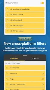
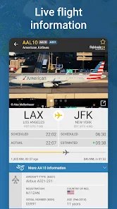
Flightradar24 Flight Tracker is a real-time flight tracking application built by Flightradar24 AB, a Swedish company that has assembled one of the largest aviation data networks in the world. The app combines signals from ADS-B receivers, multilateration, satellite feeds, and radar data to plot aircraft positions on an interactive map. Users can tap any aircraft to see its flight number, registration, aircraft type, altitude, speed, heading, and estimated route, along with a playback of the flight's path so far. In addition to live tracking, the app offers airport arrival and departure boards, a searchable flight database, weather overlays, and a 3D view in its paid tiers.
The core audience is broad but fairly specific: frequent flyers, aviation enthusiasts, plane spotters, and people who need to monitor a particular flight. The everyday problem it addresses is uncertainty. Someone waiting at an airport wants to know whether a relative's flight is delayed or already descending; a photographer wants to know which aircraft is approaching which runway; a traveler wants to confirm that a connecting flight is running on schedule. The live map answers these questions within seconds, and the airport boards make delay information visible without visiting an airline's website.
The tracking itself is the strongest element. Aircraft positions refresh quickly, and coverage across Europe and North America is dense, so most populated areas show a steady stream of traffic. Selecting a plane brings up a clean detail panel, and the playback feature is genuinely useful for understanding where a flight has been. Airport boards are well organized and easy to scan. Some extras, however, sit behind a subscription: the 3D view, extended historical data, and detailed weather layers are locked behind paid plans, and the free version inserts advertising and limits how far back you can rewind a flight. These additions are valuable for enthusiasts but are not essential for the casual user who simply wants to check a landing time.
In practice, the app fits several everyday situations. Before a pickup at the airport, a quick glance at the arrival board tells you whether to leave now or wait. During a disruption, watching an aircraft circle or divert gives a clearer picture than a vague airline notification. Plane spotters can identify an approaching airframe before it comes into view. The interface supports these tasks well, though the sheer density of information can feel overwhelming on first launch. The app is a good fit for travelers, aviation hobbyists, and anyone who regularly meets people at airports; occasional users may find the free tier sufficient and the paid upgrade hard to justify.
Key Functional Highlights
- ✨ Live map tracking: aircraft appear on an interactive map with altitude, speed, heading, and route data that update in near real time, letting you follow a specific flight or simply watch the traffic overhead.
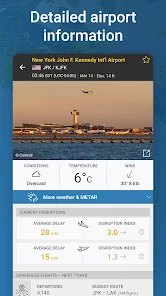
- ✨ Airport boards: arrival and departure screens for major airports show scheduled times, actual times, and status, which makes it easy to check delays without opening an airline's site.
- ✨ Flight search and details: searching by flight number or route opens a page with aircraft type, registration, photo, and a playback of the flight's path, useful for identifying a plane or reviewing a journey.
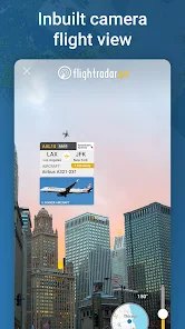
- ✨ 3D and weather views: a three-dimensional perspective and weather overlays add context about altitude and conditions, mainly aimed at enthusiasts who want a richer picture of what they are watching.
Advantages & Benefits
- ✅ Data refresh is fast and coverage in busy airspace is strong, so positions and statuses feel current rather than stale.
- ✅ The interface is clean and readable considering how much information is packed into each screen; the detail panel is logically arranged.
- ✅ Playback and airport boards turn the app into a practical tool, not just a novelty map, and support quick decisions.
- ✅ The free tier is usable for basic checks, which keeps the app accessible to casual users.
Areas for Improvement
- ⚠️ Several headline features, including the 3D view and extended history, require a paid subscription, and the free version carries advertising.
- ⚠️ Coverage depends on receiver networks and can be sparse over oceans and remote regions, so some flights appear intermittently.
- ⚠️ The volume of data on screen can overwhelm newcomers, and there is little onboarding to explain the map's symbols and controls.
- ⚠️ Weather layers and historical playback sit behind the paywall, which limits usefulness during disruption analysis for non-subscribers.
Recommended Apps
![]()
AstroMatrix Birth Horoscopes
AstroMatrix4.7

![]()
TeraBox: 1TB Cloud & AI Space
Flextech Inc.4.4![]()
Cool CallScreen-Birthday Theme
Hendrickson4.1![]()
Birthday Secrets
shasunder4.4![]()
Time Warp Scan : Face Scanner
Apps Resort - Daily Tool Apps4.4![]()
Wednesday Addams Prank Call
Prank Calling4![]()
Face DNA: AI Ethnicity Test
Ineptlyawesome4![]()
Trivia Crack: Brain Quiz Games
etermax4.5![]()
Silly Sounds: Prank Sounds App
Zenspin by Mindscape Applab llc0![]()
The Choicer Voicer
SeweSol Game1.3![]()
iCut: Video Editor & Maker
iCut -Video Editor & Video Maker App3.8![]()
Brain Test: Alzheimer's
Living Maples Healthy Aging0![]()
Pencil Sketch
Dumpling Sandwich Software Inc.4.7![]()
Scan My Teeth
Tabica Group1.8![]()
ImagineArt: AI Art & Design
Vyro AI4.3















You May Like
-
![]()
Grindr - Gay Dating & Chat
Grindr LLC4.1 -
![]()
Football Wallpaper HD 4K
Orange Infotech Studio4.6 -
![]()
Version AI: AI Photo Generator
Apptribe Dijital4.5 -
![]()
Wave Live Wallpapers Maker 3D
Live Wallpapers by Wave Studio4.3 -
![]()
MyHyundai with Bluelink
Hyundai Motor America4.6 -
![]()
Muse from Meta
Meta Platforms, Inc.4.7 -
![]()
Ask AI - Chat with Chatbot
Codeway Dijital4.5 -
![]()
SillyGlow: Smile Wallpaper 4K
BizApp Inc.0 -
![]()
Facebook
Meta Platforms, Inc.4 -
![]()
Pet Translator: Dog & Cat Talk
Revivoskin0 -
![]()
PrankGen - Funny Prank Sounds
DATONG FUN3.8 -
![]()
Cool Wallpapers HD Steampunk
Live Wallpapers and Emoji Keyboard Themes4.4 -
![]()
Simple Calendar - easy planner
Komorebi Inc.4.7 -
![]()
4D Live Wallpaper–HD Wallpaper
ZERO Tech4.5 -
![]()
Emoji background changer
Judi Studio4.4